
How goes ICAO Aeronautical Chart?
Information about the symbols on the ICAO Aeronautical Chart 1:500.000 Germany
The ICAO Aeronautical Chart 1:500,000 accompanies pilots throughout their flying life. It is an integral part of training and classic air navigation. There is a lot of information on the map. Behind some symbols there is more than meets the eye. Here we present a selection.
Die ICAO-Karte 1:500.000 begleitet Pilot:innen ihr ganzes Fliegerleben lang. In der Ausbildung und bei der klassischen Flugnavigation ist sie ein fester Bestandteil. Auf der Karte gibt es sehr viele Informationen. Hinter manchen Symbolen steckt mehr, als man auf den ersten Blick denkt. Hier stellen wir eine Auswahl vor.
Weitere Inhalte zu den ICAO-Karten:
» weiter zu: FAQ zur ICAO-Karte
Glider sites
In the depiction of glider sites, a distinction is made between sites with aerotow and winch tow and those with winch tow only. Glider sites are shown on all variants of the ICAO Aeronautical Chart. On the glider edition, however, they are highlighted in yellow for better recognition.
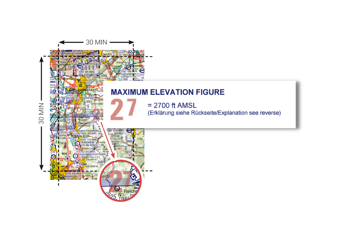
Maximum Elevation Figure
The highest elevation and the highest obstacle are compared and the higher value is displayed.
A more detailed explanation of the calculation can be found at https://www.eisenschmidt.aero/repetitioncorner (under RepetitionCorner 08/20).
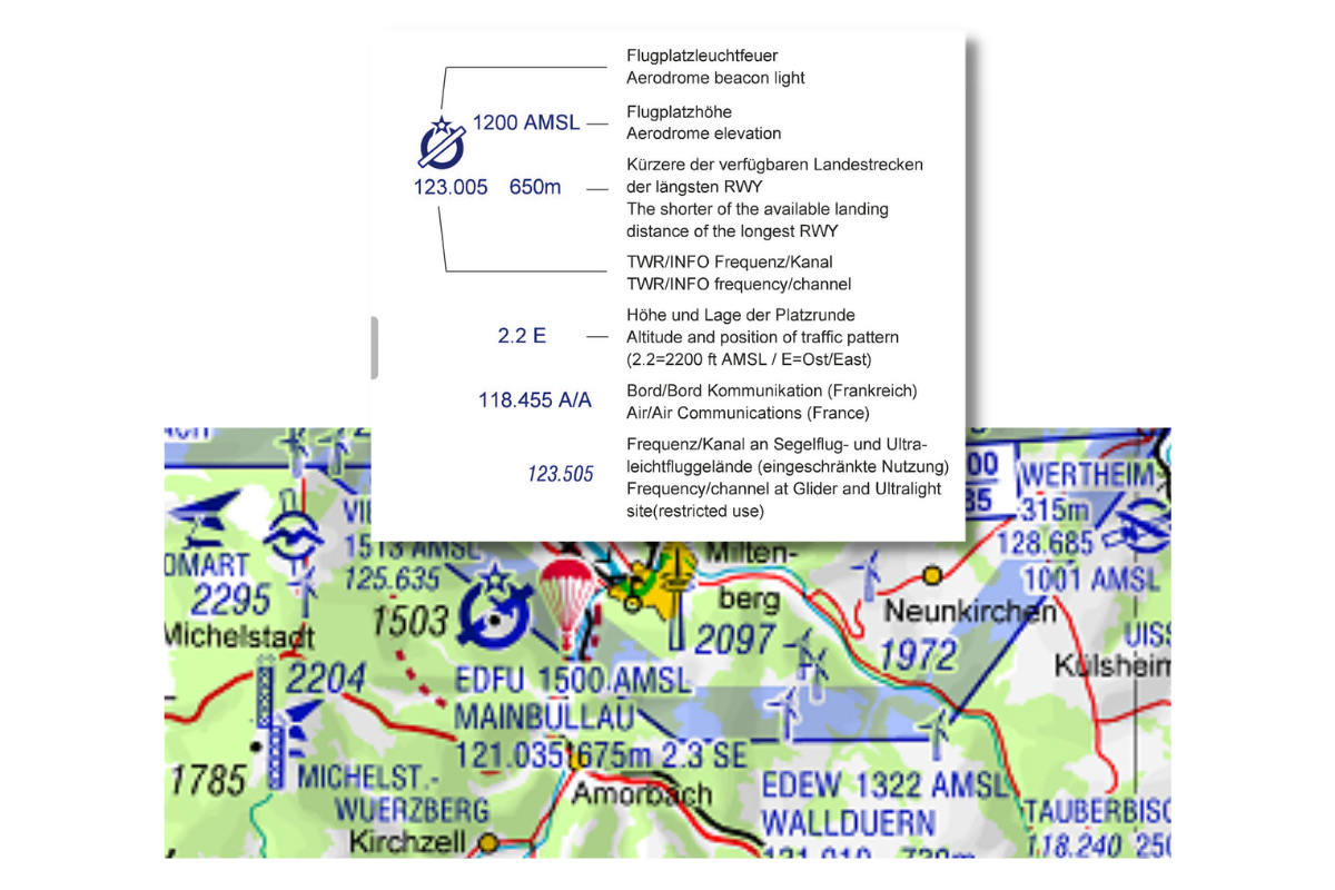
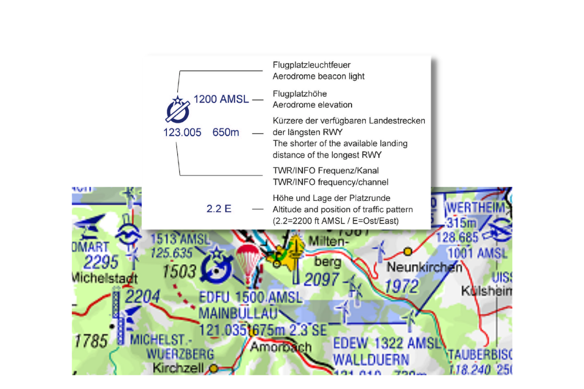
Airfield display
When displaying airfields, the most important points for a landing preparation are shown. This also allows unscheduled stopovers to be mastered.
- TWR or the INFO frequency
- ICAO designator and name of the airfield
- Airfield altitude above mean sea level
- Altitude and position of the aerodrome circuit in relation to the aerodrome. Here, 2.3 represents an aerodrome circuit altitude of 2300 ft MSL and the SE means that the aerodrome circuit is located south-east of the airfield.
- The length of the shorter of the available landing distances of the longest RWY. Thus, this landing distance should be available as a minimum.
- The star indicates if the airfield has a beacon. This can make it easier to find the airfield in poor visibility or at night.
- If flying without an air traffic controller is possible at this airfield, the term A/A after the frequency indicates this. Here, pilots regulate traffic among themselves by means of blind transmissions or agreements made among themselves. The term A/A stands for Air to Air Communication.
- If the use of the frequency is limited in time, as is often the case at glider and microlight sites, the frequency is printed in slightly italicized letters.
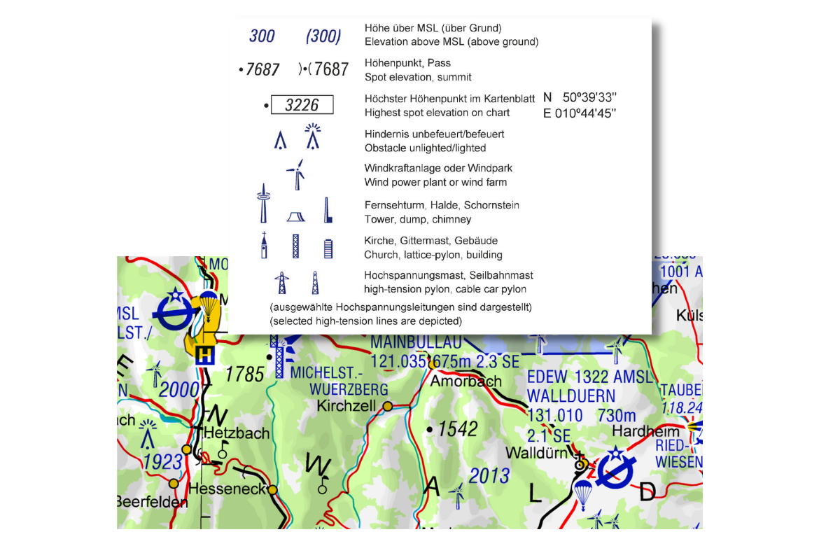
Obstacle representation
Obstacles with a height of 100 m (328 ft) above ground and more are shown on the ICAO Aeronautical Chart. By default, altitudes are above MSL, which is mean sea level. If elevations are shown in parentheses, they refer to elevations above ground level.
Elevation points (spot elevation) are shown in black with the elevation above sea level.
Obstacles are man-made, e.g. TV towers or wind turbine. The elevation refers to the highest point above sea level and is drawn in blue. The map symbols correspond as far as possible to the real appearance of the obstacles.
On each of the eight map sheets the highest point of the section is drawn. This is shown framed. It can be a natural terrain point or a constructed obstacle.
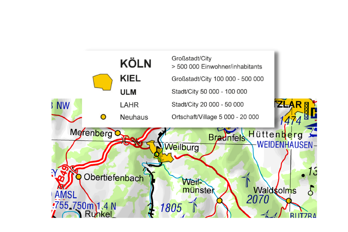
Built-up areas
From small towns to large cities: many built-up areas are shown on the ICAO Aeronautical Chart. However, only from 5,000 inhabitants. Anything smaller would exceed the scope of information of a map at this scale.
The more inhabitants, the larger the place names are printed.
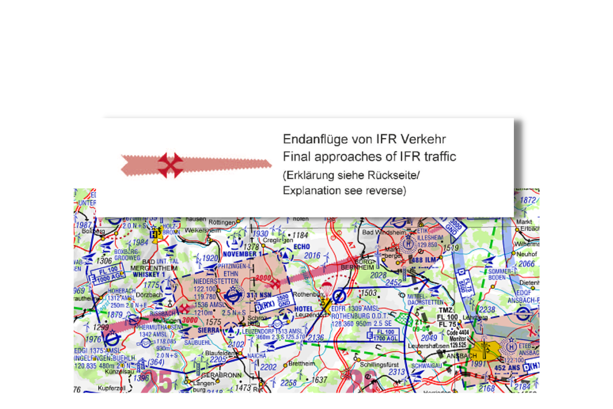
Final approaches of IFR traffic
At controlled aerodromes where no Class C or D airspace is established, IFR final approaches present themselves as particularly sensitive with respect to an IFR/VFR mixing problem. In order to increase awareness of IFR final approach areas vis-à-vis VFR pilots, the ICAO Aeronautic Chart 1:500,000 schematically depicts IFR final approaches including the respective flight level at the beginning of the final approach (indicated by a cross in red) at selected IFR airfields.
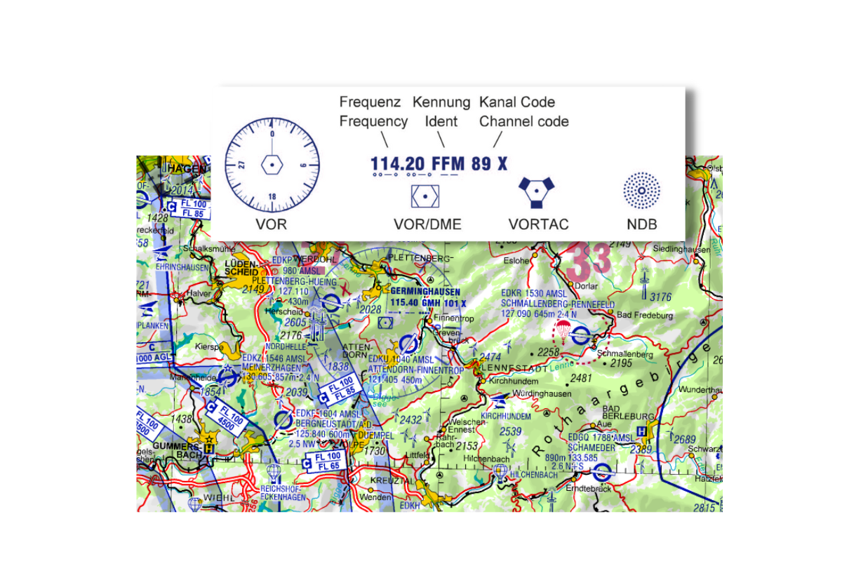
Radio navigation facilities
FRadio navigation facilities, which can be used as a means of navigation, are also shown on the ICAO chart. We distinguish between the VOR (in German: UKW-Drehfunkfeuer) and the VOR-DME. If the aircraft is equipped with a DME, the oblique distance is transmitted to us in addition to the VOR function. DME stands for Distance Measuring Equipment. The VOR-DME symbol differs from the VOR symbol only by the additional rectangle.
The Vortac can be used for civilian use as VOR/DME and for military use as TACAN. TACAN stands for Tactical Air Navigation. Last but not least, there is the non-directional radio beacon, the NDB.
For all radio navigation beacons you will find: The frequency to be used for civil use of the respective beacon, the identifier, the radiated identifier as Morse code as well as the channel frequency for military use.
Back side
It is worthwhile to turn the ICAO Aeronautical Chart upside down: On the back of the ICAO Aeronautical Chart there is helpful information.
Among other things, a coordinate ruler. When the map is face up, the edge can be folded over. Then the latitude of a particular point can be read from the degrees.
You can find an interesting article about the use of ICAO charts in practice on Sally's blog
>> ICAO charts and why I still use them in flight

Legend of ICAO Aeronautical Chart 1:500,000 Germany
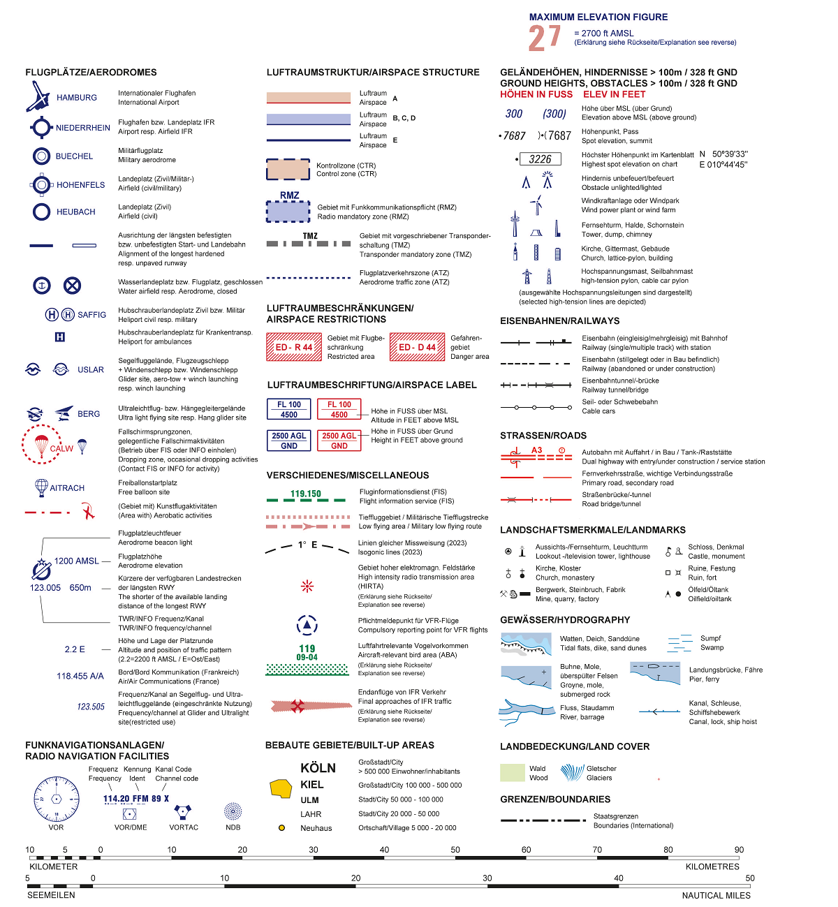
» Open PDF in new window (Copyright DFS Deutsche Flugsicherung GmbH)
How does the glider edition differ from the powered version and what's the deal with nighttime low altitudes?
Gliding:
- Altitudes are in meters, not feet.
- Glider sectors are highlighted in yellow.
- The Maximum Elevation Figure is not shown.
- Airfields with glider operations are highlighted in yellow.
Night low level flight: Night low level flight sectors marked in red are shown on the charts. Military low-level flights take place there at night. They are to be considered as restricted areas. The status (active/not active) can be obtained by radio.