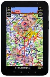
Sky-Map Android "Light" is a moving map navigation software for smartphones and tablets with Android(TM) operating system (from version 2.2).
Sky-Map Android "Light" includes the following functions:
Flight Planner maps usable: Use your existing Flight Planner map licenses. If you don't have any maps yet, you have to buy them in a flight supply store to use them in Sky-Map Android
Moving Map: Display of the position on digital aeronautical charts, e.g. the ICAO chart of DFS (not included)
Fast moving and zooming of the map
Route planning: Flights can be planned on the map or via the waypoint database.
Save / load / change routes
Calculation of distances, flight times, wind influence, fuel consumption
Automatic or manual display of approach/airfield charts if AIP is installed
Display/announcement of airspace warnings
Display of airspace and terrain section in flight direction
"Direct to" function
"Nearest Airports" function
AIP Browser: Display of the approach and aerodrome map as well as text information about aerodromes if AIP is installed
PCMet Browser: Fast access to weather information (requires paid pc_met access)
Logbook function: automatically saves start time/place, landing time/place and flight time
Infopanels (configurable) for speed, altitude, distance, time, etc.
Display optional Heading Up/ North Up
Track storage
Database Europe
Upgrade to full version possible (compare both versions)
Use your Flight Planner charts in Sky-Map Android: Please note that Sky-Map Android itself does not contain any digitized aeronautical charts. If you are a Flight Planner/Sky-Map customer and already own up-to-date aeronautical charts, you can activate them in Sky-Map Android with your chart serial number as follows
The map serial number is printed below the barcode on the original CD.
If not already done, register your software and maps with ifos. The activation of your customer account is usually done within one working day.
Now you can load your map into Sky-Map via the map serial number. Please note the terms of use for the maps.
If you do not have up-to-date digitised aeronautical charts, you must first obtain them from the air supply trade
| Manufacturer / Publisher: | ifos GmbH |


